This written course description will attempt to guide you through the course at Arroyo Verde Park in Ventura.
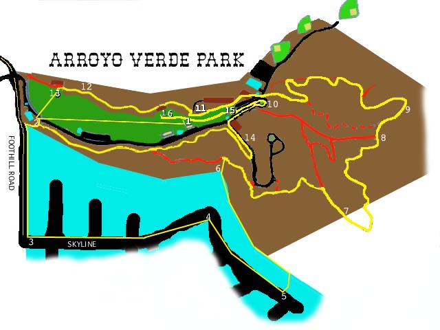
The ajoining map has numbers on it that correspond with the description in case my map doesn't make sense. Don't worry. In the race you won't have to follow this description if you don't want to--the course will be marked with paper arrows marking the correct way (though children like to move the arrows around, so pay attention--this is entirely on main trails), yellow tape will attempt to close all incorrect paths (but the bicyclists, who aren't even supposed to be on these trails, love to ride through these barriers).
On the map above, the color code is as follows: Yellow is the course, Green is grass, Black is pavement, Red are the wrong trails to take, and the Light Blue is the adjacent neighborhood and buildings in the park (bathrooms are highlighted as Purple). When the trail is in the Brown area (the park) the course is usually on dirt, except when it is on the roads (where you can hopefully see black around the line). I've done the best I can with my limited artistic skills--follow the people in front of you.
(1) The start line is between two trees, at the base of the hill that goes to the children's Fort Keller in the park. Runners go lengthwise down the grass (south) about 500 yards to the (2) short path behind the Nature Center--the house near the entrance to the park. This path is the only part of the course that is duplicated. The first time up this path, turn right to exit the park through the narrow pedestrian gate. Before the race, competitors are warned not to attempt to pass through this area. The narrow gate, path, fence, phone pole and other obstacles makes this an unsafe activity. If you want to be ahead of someone through this section, do so in the first 500 yards (I have to clean up after this race and it gets awfully messy). Leaving the gate, turn left onto the sidewalk or coned side of Foothill Road.
Go to the first road (3) Skyline and turn left. Stay on the coned left hand side of the road. The half mile mark is the far side of the first driveway on the right hand side of the street. You won't care about your time by then anyhow. This hill is impossible. My car struggles on it in first. This hill lasts four agonizing blocks--the last block is the steepest--before it levels out for about three houses before starting to rise again. Once it starts to rise, you are our beyond most traffic danger, so feel free to move to the right hand side of the road when safe. (Why do I have to be so specific, because if I'm not, stupid people might run in front of a car, say that I told them to do so and sue me--that would be a legal ordeal I don't want to go through and would cause me to have to stop putting on the race). Skyline (4) turns into Topa Topa and continues rising up hill. Two houses before the top of the hill you will turn into the special fire entrance back into the park. If my car makes it up the hill, I will be reading splits to you at this point. (5) The gate pole is the mile mark. I expect this will be the slowest mile you run this year--I haven't been dissapointed yet. Follow the path back around the houses and (thankfully) down hill until you see the yellow marking tape at the edge of the hill. If you are checking this out before the race, this path is opposite the 90 degree turn in the path behind the houses.
(6) Go down the short, steep dirt path to the main trail. Turn right. Follow this main trail as it goes down (passing a short trail from thepaved road), then up a short way to a very dusty level section before it goes up a steep section behind the water tank. Take the main trail as it makes a sharp right and levels a bit. After passing a trail coming in from the left this trail will again gradually rise until you reach the end of canyon. (7) 1 1/2 miles occurs just as the hill takes a noticible rise before it levels out. The trail then makes a sharp turn to your left and goes up a very sandy short hill. The trail then snakes down hill to the end of the lower park trail. (8) Do not take either of the easy paths that come in from the left. Take the one on your right--the one that does not look possible to run up. This particular hill is known as The Wall. You might even consider bringing your ropes and petons for this hill. Near the top of The Wall is the (9) two mile mark. The trail then turns left and levels out (at least this hill feels level after doing The Wall). Another 1/4 mile and you get to start going down hill.
Congratulations, the worst of the hills are over. On your right you will notice a new trail (that has formed over the last three years) that takes you up even more hills. Don't take this one. The main, wide trail switches back and forth. Stay on the main winding trail. Do not take the narrow short cuts that have formed between the switchbacks. Eventually you will be taken on a wide turn to your left that winds up at another main trail. Turn right and continue down hill to the park's main paved road. (10) The course comes close to another section of the course at this point. Be careful. Stay to your right as you cross the road, enter and cross the parking area and enter the Bar-B-Q area. Run just to the left of the pit and turn left just as you reach the hill. This section is usually a pile of wood debris, leaves and the like. It is not a trail, just a section of flat ground between the hill on your right and the parking lot on your left. Keep going on this past the staircase on your right, through the picnic area until you see the sign to Vista Bluff. Turn a sharp right up the short paved path and turn a sharp left (11) at the top, where the dirt trail comes in.
Stay on that main path as it goes up a short step hill then down the other side and continues down the side of the park. (12) The three mile mark is a bent metal fence post that sticks out on the left hand side of the path just past a quick dip. Shortly after that you will take a short quick downhill section that ends at (13) metal sign post (that posts a rattlesnake warning facing the other way--don't worry about the snakes, they only bite if you disturb them), turn left. around the Hazel Snodgrass picnic table area and go down onto the main grass of the park. Look across the way to see the Nature Center again. Go up the (2) same path you went up at the start of the course. This time turn left. on the path that goes along the side of the hill on the opposite side of the park from where you just ran. Go up the hill and back down. You will pass a steep hill that goes up to your right--thankfully you do not take that hill. On your left you will see the trail jumps down to the main roadway next to a fire hydrant. Don't take this either, stay on the main path up a short hill and continue along the side of the park until that trail ends at an untraveled paved road. There you turn left, downhill. ( 14) 3 1/2 miles is the phone pole before the gate. Stay on the road all the way past the Group Picnic Area, back to the main park roadway, then turn right. Stay on the right hand side of the park road as it passes the horseshoe pit, the parking area on the right. Follow the road to the right around the road island populated with palm trees. You are back near (10) so be careful. If you follow the road around the island, you are effectively making a U-Turn. Stay on the right hand side of the park road (now going the opposite direction). When you reach (15) the grass area, step up onto the grass and make as straight a line as possible directly through the center of the picnic area toward the ( 1) start line. Do not turn back up the Vista Bluff hill. Once you have passed the sign, stay close to the hill, then after passing the start line, follow the grass up hill toward the fort. About 50 yards up the hill thankfully is (16) the finish line between two trees near the top of the hill.
This is an accurately measured 4 mile course. The last time it was measured it came out as 4 miles, 57 feet--the extra 57 feet get us to a permanent marker--a tree. As best possible, the course has followed the same course for the previous ten editions of this race. If it rains, we will hold the race (it has rained twice before--it makes sorting the results much harder). Some portions of the course do get slippery, specifically the steep downhills and the paved section (the downhill at 3 1/2 miles) after your shoes have built up a residue of mud.