|
Facility Name
| Year Constructed | Curb? | Steeplechase information | ||
Cross streets or directions
Notes on unique situations and security problems Credited Manufacturer or installer Type of Surface |
Finish direction "Imperial" if track is measured in yards. | Number of lanes
Straightaway length
|
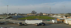
Aerial photo link courtesy of Google Maps
Altitude |
||
|
Facility Name |
Google Map link |
|||||||||||||||||||||||||
|
|
|||||||||||||||||||||||||
|
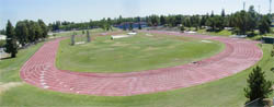
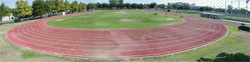
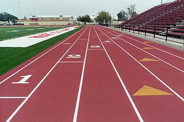
Bakersfield College |
View Larger Map |
|||||||||||||||||||||||||
|
|
|||||||||||||||||||||||||
|
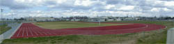
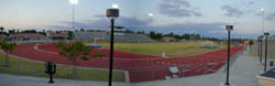
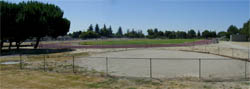
California State University, Bakersfield |
View Larger Map |
|||||||||||||||||||||||||
|
|
|||||||||||||||||||||||||


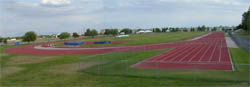
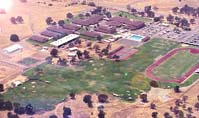
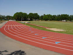
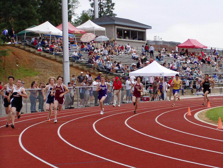
Chico |
|
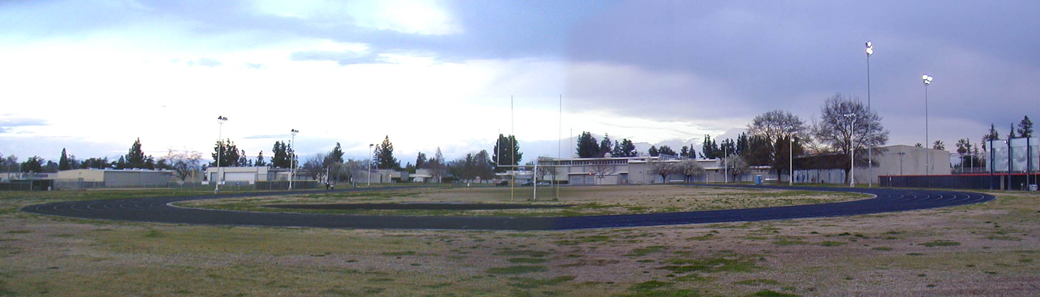
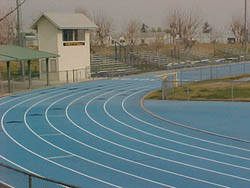
California State University, Chico
| Resurf. 2002 |
Yes metal |
Yes Inside | ||
 Warner and Legion There are two tracks a block apart from one another, the college is the one to the Southwest with an inside steeplechase, wider turns and finishes to the North. Cal Track Rekortan Resurface |
North |
8
85m
|
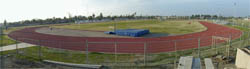
Aerial Photo | ||
|
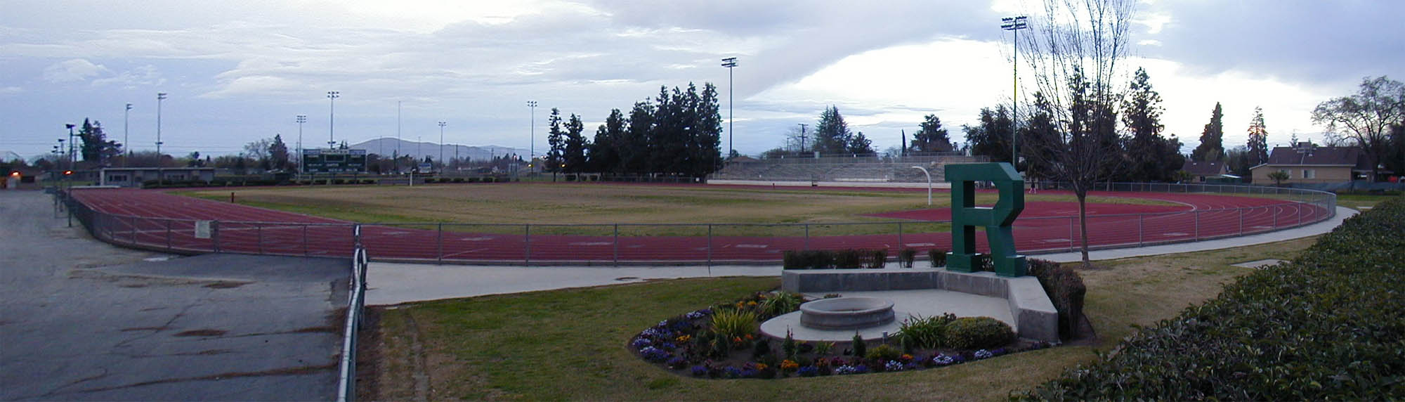
Chico High School
| No | ||||
Warner and Legion
There are two tracks a block apart from one another. This one is on the northeast corner and has tight turns and finishes to the south. |
South |
Aerial Photo | |||
| Pleasant Valley High School | No | No | |||
Ceanothus Ave. south of
East Ave. Finish line offset 10m with the 180 yd. hurdle chute apparently also surfaced, possibly from a previous surfacing. Dark Blue |
South | 8
98m
|
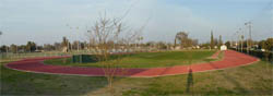
Aerial photo | ||
Oroville |
|
Butte Community College
| Yes Inside Slice | ||||
3536 Butte Campus Drive, about 10 miles
north of town
Steeplechase finishes in reverse |
South |
Map | |||
San Andreas |
| Calaveras High School | 2004 | No | No | ||
350 High School Street, north of Highway
49
It looks like a 10 meter offset finish line, with 100m straight. Link to meet pictures. |
9
|
Aerial
photo
6230 ft.
|
|||
El Dorado Hills |
| Oak Ridge High School | 2005 | No | No | ||
Harvard Way and Silva
Valley Parkway An interesting paint job, the relay passing zones are highlighted by triple wide lane lines. |
North | 9 |
Aerial
photo . |
||
South Lake Tahoe |
| South Tahoe Middle School | 1968 | No | No | ||
Lake Tahoe Blvd and Al Tahoe Blvd.
This is the track from the famous 1968 Olympic Trials that has been transported and installed here. Unfortunately I am told it is covered in snow half the year and is not available during school hours during the school year--September to June. After almost 40 years, the subsurface is breaking down and they are looking to resurface. Tartan |
South |
8
|
Aerial
photo
6230 ft.
|
||

Clovis |
|
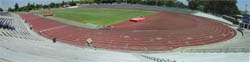
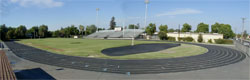
Buchanan High School |
View Larger Map |
|||||||||||||||||||||||||
|
|
|||||||||||||||||||||||||
|
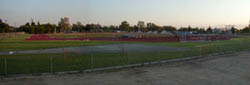
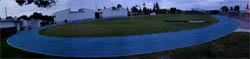
Clovis High School |
View Larger Map |
|||||||||||||||||||||||||
|
|
|||||||||||||||||||||||||
|
Clovis East High School (known
as the Reagan Education Center) |
View Larger Map |
|||||||||||||||||||||||||
|
|
|||||||||||||||||||||||||
|
Clovis West High School |
View Larger Map |
|||||||||||||||||||||||||
|
|
|||||||||||||||||||||||||
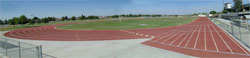
Coalinga |
|
Coalinga High School
|
May 2002 | No | ||
Sunset and Harvard between Van Ness
and Cambridge.
Cal Track Cal Trax IMS |
South |
8
100m
|
Aerial photo | |
|
Coalinga High School |
View Larger Map |
|||||||||||||||||||||||||
|
|
|||||||||||||||||||||||||
Fowler |
|
Fowler High School |
View Larger Map |
|||||||||||||||||||||||||
|
|
|||||||||||||||||||||||||
Fresno |
|
California State University, Fresno |
View Larger Map |
|||||||||||||||||||||||||
|
|
|||||||||||||||||||||||||
|
Edison High School |
View Larger Map |
|||||||||||||||||||||||||
|
|
|||||||||||||||||||||||||
|
Fresno City College, Ratcliffe Stadium |
View Larger Map |
|||||||||||||||||||||||||
|
|
|||||||||||||||||||||||||
|
Fresno Pacific University |
View Larger Map |
|||||||||||||||||||||||||
|
|
|||||||||||||||||||||||||
|
Roosevelt High School |
View Larger Map |
|||||||||||||||||||||||||
|
|
|||||||||||||||||||||||||
|
Sunnyside High School |
View Larger Map |
|||||||||||||||||||||||||
|
|
|||||||||||||||||||||||||
Huron |
|
Huron Middle School |
View Larger Map |
|||||||||||||||||||||||||
|
|
|||||||||||||||||||||||||
Reedley |
|
Reedley College |
View Larger Map |
|||||||||||||||||||||||||
|
|
|||||||||||||||||||||||||
|
Reedley High School |
View Larger Map |
|||||||||||||||||||||||||
|
|
|||||||||||||||||||||||||
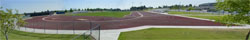
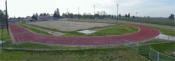
Sanger |
|
Sanger High School
|
Resurf.
2002 |
Yes concrete |
No | |
14th Street & DeWill Ave.
A 10 lane, full circumference facility with a legal curb. Cal Track Cal Trax MS |
South |
10
91m
|
Aerial photo | |
|
Sanger High School |
View Larger Map |
|||||||||||||||||||||||||
|
|
|||||||||||||||||||||||||
Bakersfield |
|
Bakersfield College
| Yes | Yes | |||
 |
Mt. Vernon and University
! The razor wire fencing makes this quite difficult to get into. Finish line offset more than 10m. |
Northeast |
9
|
Aerial photo | |
|
California State University, Bakersfield | Yes | Stationary Inside |
|||
Haggin Oaks Blvd. & Camino Media ! Barb wire surrounds this track that is locked much of the time. |
South | 8 |
Aerial photo | ||
|
California State University, Bakersfield |
View Larger Map |
|||||||||||||||||||||||||
|
|
|||||||||||||||||||||||||
| Foothill High School | No | No | |||
Park Drive and Eucalyptus
Dr. east of town It appears to be marked to run sprints backward, long chute beyond common finish. |
Northwest | m
|
Aerial photo | ||
|
Liberty High School | 2001 | No | No | ||
 |
Has an inner curb that raises the track. Jewetta Ave. and Brimhall Road. |
South | 8 |
Aerial photo | |
Ridgecrest |
| Cerro Coso College | Yes metal |
No | ||
 |
3000 College Heights Blvd.
|
East | 8 |
Aerial photo |
Taft |
| Taft Union High School | No | Stationary Inside grass |
||
 |
San Emidio and 10th Streets Blue. Open 24 hours, lit until midnight, aren't small towns great? Steeplechase has grass runway. ! has barricades . |
South | 9 |
Aerial photo |
Corcoran |
| Corcoran High School | 1997 | No | No | ||
Whitley & Letts |
South |
|
Aerial photo | ||
Hanford |
| Hanford High School | 1999 | No | No | ||
E. Grangeville Blvd. and N. Kensington
Way
Southwestern |
Southeast |
|
Aerial photo | ||
| Hanford West High School | 2005 | No | No | ||
Lacey
Blvd. and Campus Drive The track is in back on the north end of the campus |
East | |
Aerial photo | ||
Lemoore |
| Lemoore High School | 1998 | No | No | ||
|
Highway 198 & Lemoore
Ave. This track really is colored Purple. There has been an all weather track here for quite some time, dating back to the rubber asphalt days. Southwestern Eurotan |
West |
|
Aerial photo | |
Susanville |
| Lassen Community College | Old | Yes | No | ||
.
Rubber/Asphalt |
|
Map | |||
Oakhurst |
| Yosemite High School | |||||
|
Road 428 and Hangtree Lane
|
North |
8
100m
|
Aerial Photo | ||
Merced |
| Merced College | Resurf. 1999 |
Yes concrete |
Adjustable, Inside | ||
 |
M St. at Rensselaer Court (or G St.
and Yosemite)
Installed in 1995 ! I have been told access is restricted, but all that apparently means is they lock the turnstile. This is hard to find, northeast of the big stadium in the middle of the campus. Yellow Southwestern Eurotan |
South |
9
100m
|
Map | |
Napa |
| River School | No | No | |||
Underhill Road and Old
Sonoma Road (track is on the east near freeway) |
East | 9 |
Aerial Photo | ||
Grass Valley |
| Nevada Union High School | 1997 | No | No | ||
Ridge Road North of Hughes Road (stadium
is behind school)
Southwestern Eurotan |
East |
9
|
Map | ||
Auburn |
| Placer Union High School | 1995 | No | No | ||
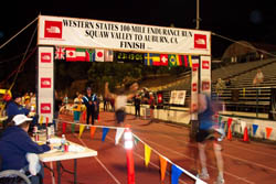 |
Finley St. and Stadium Way, East of
High Street
This is the end of the famous Western States 100 Southwestern Seal Flex |
Northeast |
9
|
Aerial photo | |
Granite Bay |
| Granite Bay High School | 2001 | No | No | ||
Wellington Way at Grizzly Way, N. or
E. Roseville Parkway
|
South |
9
|
Aerial photo | ||
Rocklin |
| Rocklin High School | No | No | |||
 |
Stanford Ranch Road at Victory Lane
(south or east of Park Lane)
I had reported it as Rubber Asphalt as I remember seeing it just a couple of years ago. Apparently it has been redone. It also looks like lane one on the sprint straight is in terrible shape. Watch this slide show and you'll get quite a tour of the track. |
South |
9
|
Aerial photo | |
Fair Oaks |
| Bella Vista High School | No | No | |||

|
Madison Ave. between
McKay St. and Kenneth St.
Check out the history of the construction of this track, good pictures Southwestern |
South |
9
|
Aerial photo | |
Folsom |
| Folsom High School | 2004 | No | No | ||
Iron Point Road just off the 50, near
the river
Yes that's 10 lanes all the way around. Fake Grass infield. |
South |
10
80m
|
Aerial photo | ||
Rancho Cordova |
| Cordova High School | Resurf. 2004 |
No | No | ||

|
Chase Drive thru Hagen Park
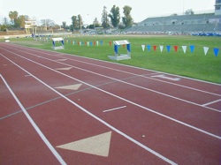
After being on the Bottom 10 for a couple of years, they've finally done the needed resurface job and also re-did the curb to make this metric in the process. The picture to the left is from a meet before they repaired it.. Cal Track |
Southeast |
8
|
Aerial photo | |
Sacramento |
| American River College | Resurf. 2005 |
Yes | Yes | ||
College Oak Drive south of Orange Grove
Ave., South Entrance
Has decent night lighting ! There is a turnstyle to enter, except it gets locked occasionally. Cal Track Rekortan Overlay |
South |
9
|
Aerial photo | ||
| California State University, Sacramento | 1998 | Yes* metal |
Adjustable Inside |
||
 |
North of 50 Freeway and Folsom Blvd.,
State University Drive W. and Stadium Way
There are actually two tracks at this location, this one is the main stadium, was used for the 2000 and 2004 Olympic Trials and the 2003 NCAA Championships. This one used the two toned mondo surface to define the relay passing zones. There are 9 lanes from the 200 start area to the common finish--at this big budget facility I don't know what logic prevented them from finishing the 9th lane the rest of the way around the track. On the south end of the infield is an astroturf area that curiously has no curb--I would think that would negate the big time records set here. Mondo |
South |
8
90m
|
Aerial photo | |
| California State University, Sacramento | 1998 | No | |||
North of 50 Freeway and Folsom Blvd.,
State University Drive W. and Stadium Way
There are two tracks at this location, this is the training track located just northwest of the stadium. It has a full width sprint straight. |
South |
4
|
Aerial photo | ||
| Grant High School | 2006 | No | No | ||
|
|
Grand Ave and Dry Creek
Road |
North | |
Aerial photo | |
| Sacramento City College (Hughes Stadium) | Yes | Yes Inside Slice | |||
 |
Sutterville Rd. at 24th Street
This has no undergone necessary resurfacing. Steeplechase finishes reverse. Wide lanes. Start lines for 2M and some other race as yet undetermined. Cal Track Rekortan M99 |
North |
9
100m
|
Aerial photo | |
Lodi |
| Tokay High School | No | No | |||
South Ham Lane opposite
Burgundy Lane, north of Century Blvd. Finish line appears to be offset some 20m. |
North | 9
m
|
Aerial photo | ||
Stockton |
| Delta College (San Joaquin Delta College) | Yes concrete |
Inside, stationary | |||
N. Pershing Ave. opposite Marco Polo
Dr.
|
South |
|
Aerial photo | ||
| Foothill High School | No |
No | |||
Windflower Lane near Holman
Road |
|
Aerial photo | |||
| Lincoln Athletic Complex |
Resurf. 2001 |
Yes metal |
No | ||
 |
W. Lincoln Rd. and Alexandria Place
Northwest of Delta College. Wide Turns. Originally built in 1994 as Southwestern Eurotan Resurface done by Cal Tracks Cal Trax MS |
West |
9
|
Aerial photo | |
| St. Mary's High School | 2000 | No | |||
N. El Dorado St. and Robinhood Dr.
Black Ocean Marker Sports Surfaces |
East |
6
|
Aerial photo | ||
Cottonwood |
| West Cottonwood MiddleSchool | No | No | |||
 |
Gas Point Rd. and Della
Lane |
South | 8 |
Aerial Photo | |
| West Valley High School | Yes metal |
No | |||
|
Happy Valley Road, north
of Gas Point Rd. Southwest of town
See schools aerial photo, including track Photo Gallery |
West |
8
|
Aerial Photo | |
Redding |
| Enterprise High School |
2000 |
No | No | ||

|
Churn Creek Road
Apparently they have installed a fake grass infield Black. Finish line offset 10m |
South |
8
|
Aerial Photo | |
| Shasta College | Yes | No | |||
|
Old Oregon Trail and Collyer
just north of 299 exit
9 lanes on sprint straight. Finish line offset 10m. Metal curb Track is not in the football stadium. See school photos |
South |
8
|
Aerial Photo | |
| Shasta High School |
2002 |
No | No | ||

|
8th Street West of Mary
Street North of school location Eureka Way (Highway
299) and Walnut Ave
Apparently they have installed a fake grass infield. Finish line offset 17m See school's track construction page |
SouthEast |
8
|
Aerial Photo | |
Shasta Lake |
| Central Valley High School | 2005 |
No | No | ||
|
Ashby
Rd. and La Mesa Ave |
NorthEast | 8 |
Aerial Photo | |
Weed |
| College of the Siskiyous | Old | No | No | ||
College Ave. west of the 5/97 interchange
Rubber/Asphalt |
8
|
Map | |||
Yreka |
| Yreka High School | Old | No | No | ||
Knapp St., 1 block west of Oregon St.
Rubber/Asphalt |
South |
|
Aerial Photo | ||
Fairfield |
| Fairfield High School | 1996 | No | No | ||
Atlantic, 1 block west of Dover, just
north of Air Base Parkway
Look at the length of that sprint straightaway. Southwestern |
North |
|
Aerial photo | ||
Suisun City |
| Solano Community College | Old | No | No | ||
 |
In terrible condition. Hard surface, worn to powder, very inconsistent. Lane lines obliterated in many places. Curb overgrown with weeds. Soccer benches and garbage cans litter lane 1 (obviously not used for competition). When I visited this was one of the windiest locations I've ever experienced. I am told this is normal. Considering the wind conditions, without constructing a huge wall this probably isn't worth salvaging. Finish line offset 20m. Rubber Asphalt |
South Imperial |
9
100m
|
Aerial photo | |
Travis Air Force Base |
| Vanden High School | No | No | |||
Whitney Drive. and Puffin Circle, East
of Peabody Rd.
Offset finish, looks imperial from afar |
South |
8
|
Aerial photo | ||
Vallejo |
| Vallejo High School | No | No | |||
west of Nebraska and Broadway
Stadium is called Corbus Field. With a fake grass infield. There is another dirt track immediately north of the stadium. |
South |
8 |
Aerial photo | ||
Petaluma |
| Petaluma High School | Yes | No | |||

|
Fair Street where it turns
into 10th Street at Douglas Street
|
Southeast |
8 |
Aerial photo | |
Rohnert Park |
| California State University, Sonoma | Yes Inside | ||||
Cotati Ave. at the east end where it
meets Petaluma Hill Rd.
|
South |
|
Aerial photo | ||
Santa Rosa |
| Elsie Allen High School | No | No | |||
Bellevue Ave. and Stony Point Road
|
North |
|
Aerial photo | ||
| Cardinal Newman High School |
2002 |
Yes | No | ||
Ursuline Road and Old Redwood Highway,
just south of Mark West Springs Road
Cal Track Cal Trax MS |
South |
6
|
Aerial photo | ||
| Santa Rosa City College | Resurf. 2001 |
No |
Yes inside | ||
| |
Mendocino and Pacific
There are two tracks at this location, the northeast track with a steeplechase is the college. The southwest track with a fake grass infield is the High School. Cal Track Cal Trax MS |
South |
8 |
Aerial photo | |
| Santa Rosa High School | 2003 |
No |
No | ||
| |
Mendocino and Pacific There are two tracks at this location, the northeast track with a steeplechase is the college. The southwest track with a fake grass infield is the High School. |
North | 8 |
Aerial photo | |
Sebastpol |
| Analy High School | No | No | |||
Johnson St. and Sunset Ave.
Black |
West |
8 |
Aerial photo | ||
Sonoma |
| Sonoma Valley High School | No | No | |||
Broadway and E. MacArthur
Black. This looks like it might be an old Rubber Asphalt |
East |
6 |
Aerial photo | ||
Modesto |
| Modesto Junior College | Yes | Adjustable, Inside | |||
| |
Tully Road and Coldwell
Home of the famous Modesto Relays. Tight turns. In order to put the finish in front of the fans in the stands; Finish line is offset 19m. Steeplechase finishes in reverse. Southwestern Eurotan |
South |
9110m
|
Aerial photo | |
Oakdale |
| Oakdale High School | 2006 |
No |
No |
||
 View Larger Map |
Bryan Ave. and J St. Surrounding a Fake Grass infield. Here's a nice website dedicated to the construction of this facility, though primarily devoted to the field. There is no discussion on how they arrived at the number of 7 lanes. Cal Track |
South | 7
100m
|
Aerial photo | |
Turlock |
| California State University, Stanislaus |
(No) |
Adjustable, Inside | |||
 |
Geer Road and Calaveras Way, north of
Monte Vista Ave.
Has a curb all the way around the track, but it never reaches the 5 cm required and dips below the track surface in some places. |
South |
9
100m
|
Aerial photo | |
Yuba City |
|
Geweke Field |
No | No | ||
| Hwy. 99 north of Bridge
St., West of Gray Ave. due to be resurfaced. |
North |
8
90m
|
Aerial photo | |
Exeter |
|
Exeter High School |
2004 | No | No | |
| Rocky Hill Dr. and Kaweah
Ave. (Hwy. 65) |
South |
9
100m
|
Aerial photo | |
Porterville |
| Porterville Community College | No | Yes, Inside | |||
College & Main, south of Highway 190
|
South |
|
Aerial photo | ||
Tulare |
| Tulare High School (Bob Mathias Stadium) | mid 80's | Yes concrete |
No | ||
 |
Tulare Ave. and Cherry Black Concrete curb. Finish line offset 10m. |
South Imperial |
9
100m
|
Aerial photo | |
Visalia |
| College of the Sequoias | late 60's or early 70's | No | No | ||
 |
Woodland & Meadow
The four lane track is the narrowest track intended for competition in the state. Tartan |
North Imperial |
4
|
Aerial photo | |
| Central Valley Christian High School | 2006 | No | No | ||
 |
Tulare and Akers Finish line offset 10M !Protected by high bar wire fences. There is an unmarked 9th lane all the way around the track, but it is only surfaced to the middle of the lane, the outside of the obviously unused lane is pavement. The coloring on this track is unique. Black with speckles of mostly white, but some blue and red. |
South | 8 99m |
Aerial photo | |
| El Diamonte High School | 2006 | Yes concrete | No |
||
 |
Tulare and Whitedale A broken back track with wide turns and short straightaways. And yes, a new track built with a proper concrete curb with drain gaps about every 5 feet. Other than extending the outfield for the third string baseball field, I can see no geographic reason why they built such a short, fat stadium or a broken back track within it. This is the first place I have seen the horizontal jump runways numbered, the west LJ runway is 1, the east TJ runway is 2. Both runways seem short, about 100 feet (particularly bad for triple jumpers). Both runways are set into the grass area over 20 feet, so the wide width that might be for soccer is negated. The runways all jump to the north, but the sprints finish to the south. Marked for 400H. |
South | 9
79m |
Aerial photo | |
| Golden West High School | 2005 | Yes metal |
No | ||
 |
Mcauliff and Houston Ave. Yes, a real metal curb at a high school track. I will say I like the soft natural grass on this infield. And on the east edge of town it is unique to hear horses whinnie nearby. ! High slat fencing make this difficult to get into. Atlas |
South | 9 101m |
Aerial photo | |
| Mt. Whitney High School | 2005 | No | No | ||
 |
Tulare and Conyer Just six blocks down the street from Redwood H.S. 9 lanes on the sprint straight. |
East | 8
102m |
Aerial photo | |
| Redwood High School | 1991 | No | Inside, fixed | ||
 |
Mineral King and Conyer
The stadium here is built into a bowl. |
East |
9 100m
|
Aerial photo | |
Davis |
| University of California, Davis | Yes | Yes | |||
|
Russell and A Street
|
South |
8
|
Aerial photo | |
Marysville |
| Yuba Community College | Yes | ||||
N. Beale Street and Alberta Ave.
The finish line appears to be offset by around 20 m. |
West |
8
|
Map | ||
Wheatland |
| Wheatland High School | No | ||||
1st Street and Wheatland
Ave. |
Southwest | 8 |
Aerial Photo | ||